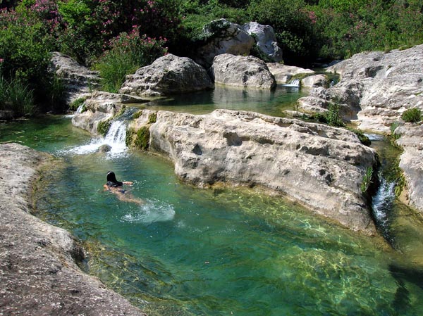
The Natural Reserve Cavagrande del Cassibile is a regional natural reserve, a true paradise where the beauty of the landscape contains the richest anthropological, hydrogeological, archeological and speleological wonders. The spectacular scenery is due to the peculiar morphology of the canyon of the river Cassibile. In the valley, it has created a complex system of small waterfalls and natural lakes, where is possible to swim.
The highest elevation reached by the plateau is 520 m above the sea level, but it is close to the viewpoint of Avola Antica, with its 507 meters, that the river reaches its maximum depth. Also in this section it reaches its maximum width of 1200 meters. In the 10 km length of the canyon, as mentioned, you can see many small lakes with cool, clear waters, among which stand out for their beauty the small lakes near Avola Antica, accessible to the public through a historical path, named Scala Cruci
As the place was defended by the inaccessible cliffs of the canyon and due to the proximity of water, the “Siculi” (ancient Sicilians), who were the first known inhabitants of this place, built two villages in the rock that are still difficult to reach and have now become part of the landscape.
Around the thirteenth century B.C. populations of south-eastern Sicily, perhaps driven by more aggressive Italic populations, preferred to take refuge in these inaccessible and well defended areas. At least two ancient villages are known: the northern one that you notice straight away from the viewpoint near the restaurant, and the southern, almost opposite. The first dates back to the X-XI century B.C., similar in beauty to that in Pantalica, has hundreds of excavated tombs and early Christian tombs carved into the walls, arranged side by side, on six different parallel levels.
The mouth of the river Cassibile is also an historical place, because the Captain Demosthenes in 413 BC with 6,000 Athenians had to surrender to the Syracusans. These places were inhabited until the first half of last century. In fact, just above the pools there was a Monastery, to which belonged the ruins of some houses owned by some old families from Canicattini Bagni that are still visible.
What makes spectacular the caves due to the flow of the water, is the morphology of the Grand Canyon of Cava Grande del Cassibile, the “Kakyparis” of the Greeks. On the north side you can see a small cluster of cave dwellings. In the south lies a complex of houses, dug into the rock, placed close together on six different parallel levels, connected by a system of tunnels and galleries. While close to the edge of the reserve, on the north-east side, there are several ancient necropolis, in which were found rich funerary furniture and ceramics. The unique decoration of those ceramics, named “feathery” or “marbled”, is part of the Ausonian culture present in the Aeolian Islands and Eastern Sicily around 1.000 B.C.
INDICATIONS
Can be reached only by car/motorbike (20-30 minutes from Syracuse)From the hostel go right, go past the train station, via Ermocrate and go over the big roundabout towards “Noto-Avola” and all the directions (Catania included). Continue past the cemetery with a first set of traffic lights, and past the second traffic light. Keep on going straight ahead. When you see the blue sign to Catania (on the right) slow down a bit but continue past the exit Catania, and after 100 meters take the first left (following the green sign to Gela-Noto-Avola Rosolini: it is the same road to Catania but in the opposite direction).
Once on the motorway Siracusa-Noto-Avola-Rosolini, take the exit CASSIBILE and then take the SS115 to Avola. From there, continue straight ahead and and turn right when you see the signs for "Avola Antica" or "Cavagrande del Cassibile" or "Laghetti di Avola" (it is the same place). After a few kilometers of mountain road you will get to the viewpoint where a restaurant is located and where you can park the car. From there take the path most commonly used by visitors, called "Scala Cruci" to do gown to the lakes. Ask for information if you want to go elsewhere (ancient villages are difficult to reach and you need proper equipment).
Tips:-Wear hiking shoes or tennis shoes (you can not go with sandals)
-The main trail called "Cruci Scale" is accessible from 8.00 am to 19.00 from spring to autumn.
-Bring drinkable water
-Path not recommended for individuals with respiratory diseases, heart diseases, allergies, and for pregnant women
-In case of rain, the reserve will be closed the following 2-3 days
-The mobile phone networks work very poorly inside the reserve
-Especially in summer it is better to go down during the cooler hours (until 10.30) and go back after 17.00
-GPS coordinates: N 36 15 E 58'6 .40 5'35 .13
-Phone number of the Reserve: 0039 0931 67450.