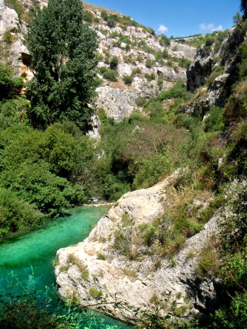
The Anapo river - whose name, of Greek origin, means "invisible" – has its source in the territory of Palazzolo Acreide (in the place called Sources Guffari on Mount Lauro), and initially flows through a deeply eroded valley, which widens and narrows. Close to the town of Palazzolo, the valley begins to show the characteristic shape of a canyon, slipping through layers of hard rock in which it has excavated tortuous and steep paths with narrow and high meandering walls, known as Gole (Gorge) di Pantalica. It is here in this area - after the bridge of Cassano-Ferla and the meanders of the district of Giambra, in the town of Sortino - that is located the world famous Necropolis of Pantalica, one of the largest in the Mediterranean regions, with its hive of thousands of ancient tombs distributed along the rocky walls, used from prehistorical ages to the early Christian era.
Today much of the Anapo valley, including the area of the necropolis, is protected by the Naturalistic Reserve Pantalica and Anapo Valley. From the naturalistic point of view, the predominant vegetation is the typical Mediterranean maquis. In the valley there are the typical “oriental” plane trees, black and white poplars, willows, and a rich and fragrant underwood; the less steep slopes are colonized by large oaks and holm oaks. In the flattest areas it is spectacular the explosion of spring flowers, iris, crocuses, daffodils and many species of wild orchids. The area is populated by mammals (foxes, rabbits, weasels, martens, porcupines), birds (falcons, buzzards, eaglea, red kitea, long-tailed bushtits, dippers), reptiles, among which the leopard snake, and insects, like the black dragonfly.
A series of paths closed to cars allow to go trhough the valley to reach the archaeological site of Pantalica. The settlement of Pantalica grew up on the ledge at the confluence of the Cava Grande torrent valley and the Anapo river valley. This ledge is connected to the plateau located behind only by a narrow isthmus, called Sella di Filipporto, or "Gate of Pantalica". The hill lies with high cliffs overhanging the bed of the two rivers, wedged in narrow gorges. The vast backdrop of five separate necropoles, precious remains of prehistoric cities, is marked by thousands of burial caves carved into the cliffs. The oldest (the necropolis north-west and the vast northern necropolis) date back to the XI-XII centuries BC, while the most recent (the side groups called Filipporto and La Cavetta) date to the centuries between the ninth and eighth B.C. Of the ancient town are still visible the ruins of the megalithic royal palace, or Anaktoron (VIII century BC), at the midpoint of the plateau overlooking the valley, and the fortifications of Porta Pantalica.
The city was founded by indigenous pre-Greek populations coming from the coast and developed at the end of the Bronze Age and beginning of Iron Age. However, the name Pantalica is Byzantine (historical phase of which are preserved many vestiges: houses, tiny churches and oratories), while the ancient name is not revealed by the historical sources: according to some theories Pantalica could identify with the ancient Hybla, the main settlement of the area in the Pre-Greek period.
INDICATIONS
Dall'Ostello andare a destra, superare la Stazione Ferroviaria, percorrere Viale Ermocrate e proseguire dritto in direzione Noto Avola Catania. Dopo 7 km circa, superato il cimitero e il semaforo, imboccare la SS114 diretta a Catania (cartello blu). Uscire a Sortino (20 km – 10 minuti) e prendere l'unica strada in direzione Sortino. Giunti a Sortino, seguendo le indicazioni “pantalica lato Sortino” si giunge attraverso l'unica strada di 5 km presente, al primo accesso della riserva. Parcheggiare il mezzo e scendere giù, con una passeggiata di circa 1 ora e mezza attraverso le tombe antiche, fino al fiume. Dopo di che si può agevolmente risalire all'accesso, riprendere il mezzo e tornare a Sortino.
PERCORSO LATO FERLA
Sortino can be reached by AST bus but from there there are no connections to Pantalica. So the reserve can be reached only by car/motorbike (25-35 minutes from Syracuse)
SHORT TRACK SORTINO SIDE
From the hostel go right, go past the train station and proceed on via Ermocrate and go over the big roundabout taking the road towards “Noto-Avola” and all the directions (Catania included). Continue past the cemetery with a first set of traffic lights, and past the second traffic light. Keep on going straight ahead. After about 7 km, go past the cemetery and the traffic lights, take the SS114 to Catania (blue sign). After about 20 km (10 mins) take the SORTINO exit and from there take the only road to Sortino (about 8-10 kms). Once in Sortino, follow the "Sortino Lato Pantalica" sign which leads you to the only road (5 km) which gets to this access to the reserve. Park your vehicle and enter the reserve walking about 1 ½ hours through all these marvellous ancient tombs (you can visit them inside!), in this incredible naturalistic paradise, until you get to the river with its pure water, where swimming is a great pleasure, especially in summer. It might be possible to cross the river and get to the other part of the reserve but the risk of getting lost is high. Better to come back though the path to the access point, take the car/motorbike and return to Sortino, from where you can continue your exploration of the site going to the Ferla side of the reserve
ROUTE FERLA SIDE
From Sortino take the road to Ferla, beautiful in late winter and spring for the lush vegetation and almond trees in their full blossom. Once you get to Ferla (about 25-30 kms) follow the signs to Pantalica. After 9 km you can park near Sella Filiporto (yellow sign), an ancient city entrance, where you can see the remains of the trench of the ancient fortification. Take the path that runs along the south side of the plateau (looking back you will see, in a sort of large natural amphitheatre, the Rocky Necropolis of Filiporto. Continuing, the route offers superb views of the Anapo gorges below and reaches a Byzantine village with rupestral dwellings on a rectangular plan and the Oratory of S. Micidiario. Follow the path and, after about 1 km, turn left to reach the Anaktoron or Prince's Palace, reachable also taking the car and continuing on the road for 1.5 km (see the left side of the North-West necropolis) and then taking a short trail (yellow sign). These are the remains of a building built with megalithic techniques, which, due to the clear Mycenaean influences was attributed from Paolo Orsi to workers at the service of the Mycenaean Prince. To proceed take the car. After 11 km from Ferla the made up road ends (note just before the Byzantine village of Cavetta) and you can then take a path down which offers impressive views of the gorge Calcinara and allows to admire the necropolis, which appears on the north rock wall opposite (20 min. walk to the bed of the river).
OLD RAILWAY TRACK- FLORIDIA SORTINO SIDE
From the hostel go right, go past the train station and proceed on via Ermocrate, then go over the big roundabout taking the road towards “Noto-Avola” and all the directions (Catania included). Continue past the cemetery with a first set of traffic lights, and past the second traffic light. Keep on going straight ahead. After about 7 km, go past the cemetery and the traffic lights, ignore the blue sign to Catania and go straight ahead to Floridia. Once in Floridia take the Provincial Road SP30 Floridia-Sortino. After about 12 km, before getting to Sortino, when you see the yellow-brown sign “Valle dell'Anapo” go left at the junction. after about 1 km turn left – lane with a red woodenand, after a few miles , you reach the wooden house where the nature trail begins. As there are not enough indications (and sometimes they are not replaced) it is better to first google-map all the route and in case you don't find the entrance of the reserve, try to get information from whoever you meet there (there is an agritouristim nearby called Sacre Pietre). It is necessary to bring a pocket torch to walk along the ancient railway tunnels.